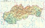
The village is situated in the region called Zamagurie, in the valley of the Havka creek, joined with the Červený Kláštor (Red Monastery). It was founded by the Berzeviczy family at the beginning of the 13-th century as a result of Šoltýs colonization. According to a document from the year 1319, master Kokoš donated 62 sectors to the Cartesian monks from the “Rock of Refuge” (currently known as “Monastery” in the Slovak Paradise). The rest was sold by Šoltýs Ján from Plaveč to Cartesians in 1325. In 1612 Juraj Horváth from Plaveč bought the land of the Red Monastery and became the owner of the village.
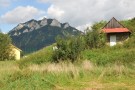
In past, most of the local population were farmers, carriers and seasonal workers. Nowadays they work mainly as farmers. Václav Vraný, a botanic researcher, writer and keeper of the museum in Martin, worked in the village as a teacher.
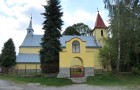
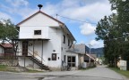
In the village there is a Roman-Catholic church from the beginning of the 14-th century (surrounded by walls). It was rebuilt in the 19-th century. You can notice a wooden belfry and rustic houses with blue pained joints and saddle-shaped roofs. They were built in a chain along the creek.